Architecture, Engineering, and Construction (AEC)
Using drones for crop mapping involves capturing aerial data to assess and monitor the health and growth of crops, aiding farmers in informed decision-making for better agricultural management.
Benefits Of Architecture, Engineering, and Construction (AEC)
Architecture Engineering
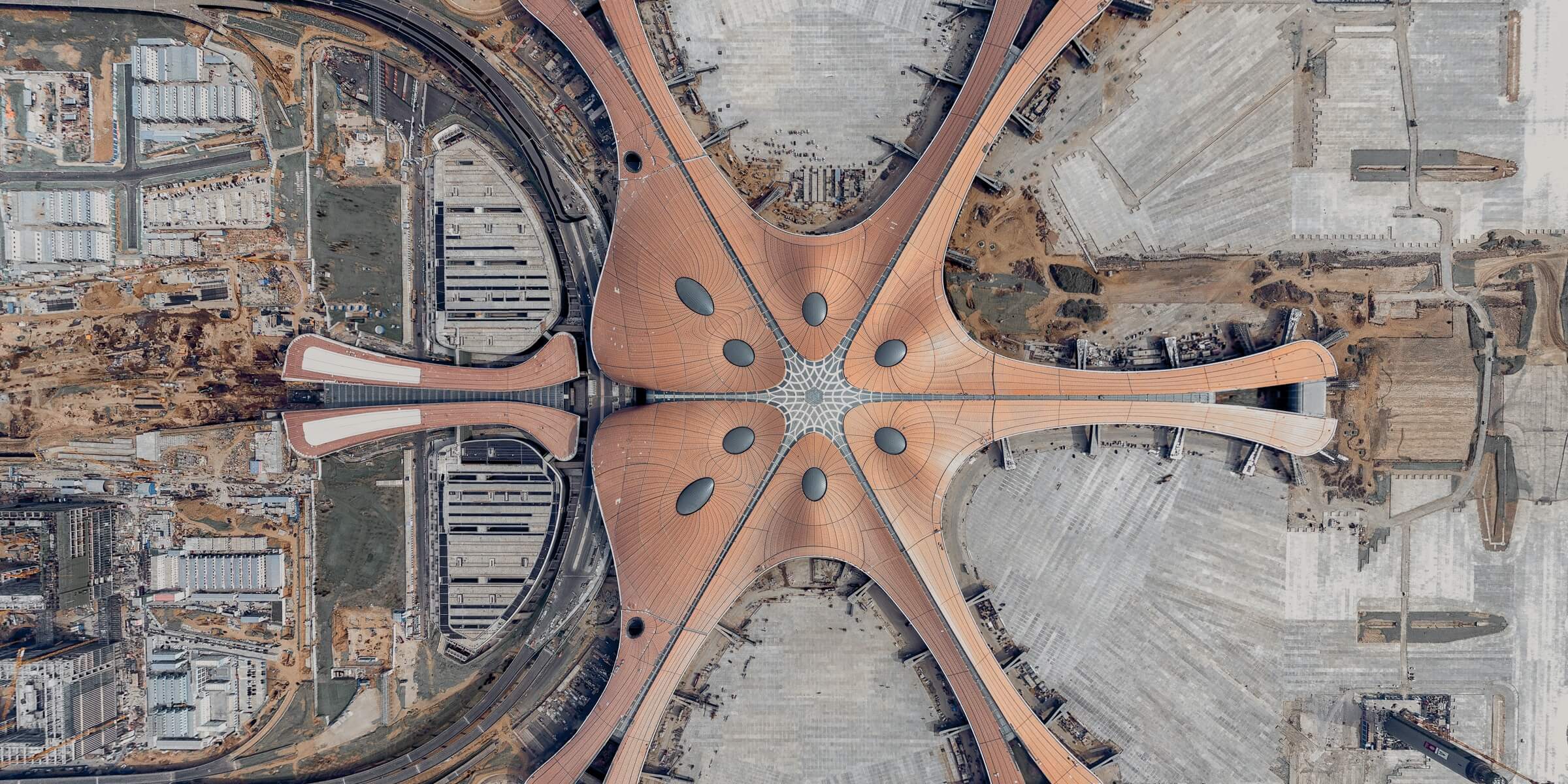
Map large work sites to acquire detailed, precise data using drones. 2D maps and 3D models help teams optimize project planning and designs.
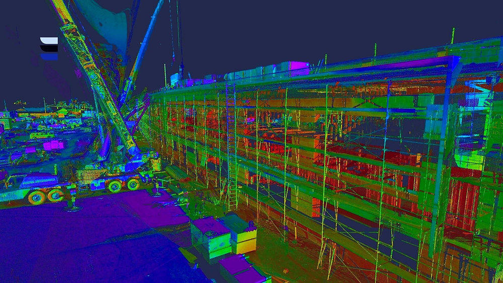
Progress Monitoring
Drone solutions, along with image stitching and 3D modeling software help teams stay fully informed on site progress and resource allocation – keeping projects on time and on track.
Stockpile Volumetrics
Obtain accurate volume measurements of stockpiles and construction aggregates using 3D models built with aerial images.
Using Drones

Challenges
- Regulatory Compliance: Meeting and navigating stringent aviation regulations is a significant challenge. Ensuring compliance with local, national, and international drone regulations adds complexity to AEC projects.
- Skill Shortages:The AEC workforce may lack the necessary skills to operate and interpret data from drones effectively. Training professionals to use this technology proficiently is essential for successful implementation.
- Data Integration: Integrating drone-derived data into existing workflows, such as Building Information Modeling (BIM) systems, can be challenging. Ensuring seamless compatibility with other tools used in the AEC industry is crucial for efficient project management.
- Data Security and Privacy: Managing and securing the vast amounts of data collected by drones is a concern. Protecting sensitive project information from unauthorized access and addressing privacy issues related to aerial surveys are paramount.
- Costs and Return on Investment : While drone technology offers benefits, the initial investment in equipment, software, and training can be substantial. Ensuring a positive ROI and demonstrating the economic value of drone technology remains a challenge for some AEC firms.
- Technology Integration: Handling and processing large datasets generated by drone surveys requires specialized software and expertise.Integrating drone technology with other emerging technologies, such as augmented reality (AR) or virtual reality (VR), can be complex. Coordinating the use of multiple technologies to enhance the overall AEC workflow requires careful planning.
- Environmental Conditions: Adverse weather conditions, such as high winds, rain, or extreme temperatures, can disrupt drone operations. Ensuring reliable data collection under various environmental circumstances is a challenge.
- Public Perception: Drones flying over construction sites may raise concerns among the public regarding safety, privacy, and noise. Managing public perception and addressing community concerns is essential for successful project implementation.
How Works
- Project Planning: Define the objectives of drone use in the AEC project, such as surveying, monitoring, or mapping. Determine the specific areas or aspects of the construction or design process where drones will be employed.
- Regulatory Compliance: Research and adhere to local drone regulations, obtaining necessary permits for AEC drone operations. Develop protocols to ensure compliance with airspace restrictions and safety regulations.
- Drone Selection:Choose drones with suitable specifications for the project, considering factors like payload capacity, flight time, and sensor capabilities. Select sensors (cameras, LiDAR) based on the data required for construction site mapping, surveying, or monitoring.
Data Acquisition: Deploy drones to capture high-resolution imagery, topograp hic data, or 3D models of construction sites. Execute planned flight paths to ensure comprehensive data coverage, considering the specific requirements of the AEC project.
Real-time Monitoring:
Monitor drone flights in real-time to ensure they adhere to planned trajectories. Address any issues or deviations promptly, ensuring data quality and safety.
- Data Processing: Transfer captured data to a computer for processing using specialized software. Stitch together images, process LiDAR data, or create point clouds to generate accurate and detailed representations of the construction site.
- Integration with BIM: Integrate drone-derived data into Building Information Modeling (BIM) systems or other project management software. Ensure compatibility with existing tools used in the AEC workflow for seamless data integration.
- Collaboration and Communication: Facilitate collaboration among project stakeholders by sharing drone-derived data for informed decision-making. Communicate findings and insights from drone data to architects, engineers, and construction teams.
Explore More Content
In the Architecture, Engineering, and Construction (AEC) industry, the integration of drones has become a transformative force, addressing challenges and unlocking new possibilities in project planning, execution, and data management. The process of leveraging drones in AEC involves a series of strategic steps.

Integration with Building Information Modeling (BIM) systems follows, allowing seamless collaboration and communication among project stakeholders. The compatibility of drone-derived data with existing tools in the AEC workflow is essential for holistic project management.
At the outset, project planning is paramount. A clear definition of objectives for drone utilization, whether it be site surveying, construction monitoring, or mapping, sets the foundation for successful integration. Additionally, understanding the regulatory landscape is crucial. AEC professionals must navigate and comply with local drone regulations, securing necessary permits and ensuring adherence to airspace restrictions.

Real-time monitoring ensures that drone flights adhere to predetermined trajectories. This allows for immediate intervention in case of deviations, ensuring data quality and flight safety. Post-capture, data processing is conducted using specialized software, transforming raw imagery and sensor data into detailed representations of the construction site, including 3D models and point clouds.